
Welcome to Petrified Forest National Park
Welcome to the Petrified Forest National Park Information Page.
Here you will find all you need to know about the natural history of the park.
Learn about the geology, trees, mammals, birds, or other plants and wildlife of the area.
Petrified Forest National Park is located in northcentral Arizona, just off of I-40, about 18 miles west of Navajo, Arizona and about two hours east of Flagstaff, Arizona and about one hour west of Gallup, New Mexico.
Getting to Petrified Forest National Park
The closest airports are located at Flagstaff and Phoenix, Arizona and Albuquerque, New Mexico.
From the North
1. Take Highway 89 South to I-40 East to the park.
2. Take Highway 666 South to I-40 West to the park.
From the East
1. Take I-40 West to the park.
From the South
1. Take Highway 180 North to the park.
From the West
1. Take I-40 East to the park.
Transportation
Bus service is not available. Private vehicle or commercial tours only.
Establishment the Petrified Forest National Park
Petrified Forest National Park was first established as a National Monument on 08 Dec 1906 when Teddy Roosevelt signed the proclamation. Congress passed a bill that elevated the monument into a national park in 1962.
Size and Visitation of Petrified Forest National Park
Acreage – as of September 23, 2000
Federal Land – 93,532.57
Non-Federal Land – 0.00
Gross Area Acres – 93,532.57
About one half of the visitation occurs during June, July and August. The visitation for 1996 was 829,615. Visitation for 1999 was 666,978.
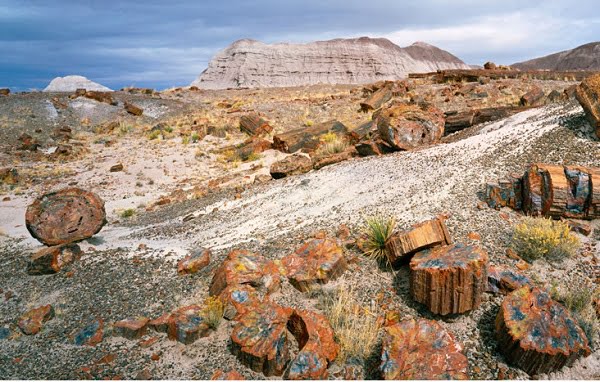
Petrified Trees
Imagine a large basin area with numerous rivers and streams flowing through lowland. A lush landscape with coniferous trees up to nine feet in diameter and towering almost two hundred feet tall surrounds you. Ferns, cycads and giant horsetails grow abundantly along the waterway, providing food and shelter for many insects, reptiles, amphibians, and other creatures.
During the Triassic Period (200 – 250 million years ago) the Colorado Plateau area of northeastern Arizona was located near the equator and on the southwestern edge of the landmass known as “Pangea”. (Eventually this super-continent separated to create our present continents.) This tropical location resulted in a climate and environment very different from today. Fossil evidence of this ancient land lies in the sediments called the Chinle Formation that is now exposed in Petrified Forest National Park.
Over time, trees died or perhaps were knocked over by floodwaters or wind. Rivers carried the trees into the lowlands, breaking off branches, bark, and small roots along the way. Some trees were deposited on the flood plain adjacent to the rivers and others were buried in the stream channels. Most of the trees decomposed and disappeared. But a few trees were petrified, becoming the beautiful fossilized logs we see today. Most of the fossilized logs are from a tree called Araucarioxylon arizonicum. Two others, Woodworthia and Schilderia, occur in small quantities in the northern part of the park. All 3 species are now extinct.
History of Petrified Forest National Park
Sites throughout the park tell of human history in the area for more than 2,000 years. We don’t know the entire story, but there were separate occupations, a cultural transition from wandering families to settled agricultural villages, pueblos, and trading ties with neighboring villages. Then this story of early people, told by potsherds, rubble, and pictures on the rocks, fades around 1400 AD.
In the mid-1800’s US Army mappers and surveyors came into this area and carried back East stories of the remarkable “Painted Desert and its trees turned to stone.” Next, farmers, ranchers, and sightseers made their ways into the area. After a period of using the wood for souvenirs and numerous commercial ventures, territorial residents recognized that the supply of petrified wood was not endless. In 1906 selected “forests” were set aside as Petrified Forest National Monument. In 1932 some 1,000 hectares (2,500 acres) more of the Painted Desert were purchased and added to the monument. In 1962 the area became Petrified Forest National Park, and in 1970, 20,250 hectares (50,000 acres) were further set aside as wilderness.
Visitors Guide
Accessibility
All major facilities, including concessions are accessible. Portions of some trails are accessible (Giant Logs, Puerco Pueblo).
Basic Recommendations
I recommend that you plan your trip and the areas you would like to see and then go and relax and make a day of it. Go and see all that is in the area and enjoy it. You spend more quality time and learn and see more than you could ever imagine.
Petrified Forest is a surprising land of scenic wonders and fascinating science. The park is located in northeast Arizona and features one of the world’s largest and most colorful concentrations of petrified wood. Also included in the park’s 93,533 acres are the multi-hued badlands of the Painted Desert, archeological sites and displays of 225 million year old fossils.
Camping
There are no campgrounds in the park but they are available in nearby communities. Overnight backpacking is allowed in the Painted Desert wilderness. A permit is required and can be obtained for free at the visitor center or museum.
Prevention:
- Avoid sick or dead animals and rodent nests or borrows.
- Do not approach any park animal.
- Teach children to avoid dead animals and rodent nests or burrows.
- Do not allow dogs and cats to roam free; minimize or prevent their interaction with wild animals. Be sure to immunize your pets.
- Dust dogs and cats with insecticide powder to prevent transportation of fleas into homes or vehicles. Use insect repellent on clothes.
- Reduce and eliminate rodent populations in and around homes and other buildings.
- Wear protective gloves and mask; don’t breathe dust around rodent urine and feces. Use bleach or other disinfectant when cleaning areas around rodent traps. Throw the traps out with the carcass. (Employees:
- Anyone handling dead animals must wear gloves).
- Cats are very susceptible to plague and rabies. Be cautious when handling sick cats with possible exposure.
- See a doctor immediately if exposed to any of these potentially fatal diseases. For more information, contact your local health department.
Entrance Fees
- Individual Entry (Bike, Foot) $ 5.00 (Seven Day Pass)
- Private Non-commercial Vehicle $ 10.00 (Seven Day Pass)
- Private Non-commercial Vehicle $ 20.00 (Annual)
- Gold Access Passport
- (Blind or permanently disabled individuals)* Free (Lifetime – good in all national parks)
- Golden Age Passport
- (one time fee – for those 62+ years young)* $ 10.00 (Lifetime – good in all national parks)
- Golden Eagle Passport (good one year from date of purchase) $ 50.00 (good in all national parks)
Golden Access Passport
The Golden Access Passport is a free pass available to all permanent U.S. residents who are eligible to receive federal benefits based on disability, whether or not you are actually receiving them or not. This pass entitles the bearer, and immediate family or accompanying passengers in a private vehicle, to free admission to all U.S. National Parks, Monuments, Forests, and Historic Sites, as well as half price camping. Apply in person at any National Park Service or U.S. Forest Service area.
Food and Supplies
At the north end of the park is the Cougar Cafe and a gas station that features a travel store. The Rainbow Forest Curio Shop, at the south end of the park, has packaged foods and a snack bar.
Hiking Information
Petrified Forest National Park backcountry includes 50,260 acres of established wilderness. Day hikes are the most popular way to explore the backcountry. Many features can be reached in one day trip, most lying within a few miles of the park road. There are no developed trails in Petrified Forest wilderness, so most hiking is cross country style. Clear air, a lack of heavy vegetation, and a variety of landmarks combine to make conditions excellent for this type of hike. Since water and shade are not available, hikers should carry their own. A wide brimmed hat and long sleeve shirt will provide good sun protection.
A gallon of water per person per day is recommended in summer months. Good sturdy shoes will make hiking in the park’s loose sand and loose clay more comfortable. Topographic maps and more detailed information are recommended for hikers planning extended trips. Just park in any designated pullout in the park and you can be on your way to a deeper understanding of Petrified Forest. The entire park boundary is fenced and most of the surrounding land is privately owned. Please get permission from landowners before hiking on their lands.
Lodging Information
There are no lodging facilities or campgrounds in the park but they are available in nearby communities.
Pet Information
Pets: Leaving your pet in a parked car can be a deadly mistake. On a warm day, the temperature in a parked car can reach 160 degrees in a matter of minutes, even with partially opened windows. Breathing this hot air, your pet can quickly suffer brain damage or die from heatstroke.
Signs of heat stress are: heavy panting, glazed eyes, rapid pulse, dizziness, vomiting, deep red or purple tongue.
If your pet gets overheated, you must lower its body temperature immediately by:
- Placing your pet in shade and applying cool (not cold) water all over its body.
- Applying ice packs or cold towels only to head, neck and chest.
- Letting it drink small amounts of cool water, or lick ice cubes or ice cream.
- Immediately taking your pet to a veterinarian.
Permits
A free permit must be obtained for overnight wilderness camping. Permits are available at the Painted Desert Visitor Center or the Rainbow Forest Museum. Commercial photography requires a permit and it must be obtained well in advance or your visit.
Safety
High Elevations: Visitors unaccustomed to high elevations may experience mild symptoms of high altitude sickness. These include nausea, dizziness, headache, rapid heartbeat, and shortness of breath. Minimize these effects by increasing fluid intake, avoiding alcohol and cigarettes, eating lightly and frequently and getting plenty of rest. Ultraviolet radiation is also a threat at high elevations. Wear sunglasses with ultraviolet protection, a hat, long-sleeved garments, and use sunscreen to prevent sunburn.
Keep Wildlife Wild: Never feed wildlife. By luring wildlife into traffic areas they are frequently hit by cars. Wildlife can become dependent on human food, and even lose the ability to hunt. Wildlife carry diseases such as rabies, hantavirus or bubonic plague that can be transmitted to humans. Photograph all wildlife from the safety of your vehicle or from the roadside. Observe wildlife quietly; approaching them frightens them away.
Watch Your Step: Many accidents happen when people fall by stepping off trails or roadsides, or by venturing onto steep slopes. Stay on designated trails and don’t go beyond protective fencing or guardrails. Supervise children closely in such areas.
Lightening: Afternoon thunder and lightning storms are frequent during summer. Thunder, darkening clouds and changes in wind velocity and direction are indicators of an approaching storm. Avoid high observation areas, open areas, and rocky overhangs during thunderstorms. If you are caught in the open, squat with your hands on your knees, keep your head low, and wait for the storm to pass.
Hiking and Backcountry Travel: Be prepared for all types of weather. Unforeseen conditions can change a short hike into an unpleasant adventure. Severe storms can impose wilderness hazards even a short distance from your car. Do not attempt to cross water filled washes. Always carry protective clothing even when the weather does not appear threatening.
Visitor Facilities
- Painted Desert Visitor Center (north end) has a 20 minute Orientation film.
- Painted Desert Inn NHL – has exhibits, bookstore and expansive view of the Painted Desert.
- Rainbow Forest Museum (south end) has exhibits of petrified wood and of the area’s geological story and human history.
Petrified Forest National Park Weather Information
Summers are generally hot with temperatures in the 90’s and occasionally in the low 100’s. In winter the highs in the 40’s or 50’s, or much colder with highs only in the 20’s. Annual rainfall is 9 to 10 inches with 40% occurring as thunderstorms in the late summer. There is occasional snow in the winter. High winds can happen any time of year. Humidity is usually low.